Devonport Military History Trail
Named after the Devonport naval base in England, Devonport is home to the Royal New Zealand navy and is rich in maritime history. The Military History Trail will introduce you to Devonport’s historical connections with the military service from the beginning of the European settlement, Devonport’s role in the development of the New Zealand Navy, and stunning views from Devonport’s volcanic cones. Devonport is also home to the highly acclaimed Torpedo Bay Naval Museum, which has one of New Zealand’s largest collections of naval history resources.
This trail takes between two and three hours to complete (more if you choose to visit Fort Takapuna), although it is up to you how long you wish to spend at each location.
Windsor reserve
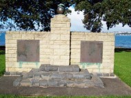
The Military History Trail begins at Windsor Reserve, the park that is next to the Devonport Wharf. This park also goes by the name of Flagstaff due to its historical connections with the navy. The British navy landed at this site in 1840 and began the European settlement of Devonport. Originally, the park was home to a small naval unit with barracks, ship repair workshops and stores for gunpowder and later torpedoes. Today a large commemorative flagstaff and plaque can be seen near the waterfront acknowledging Windsor Reserve’s connections with the New Zealand Navy.
King Edward Parade
Walk through the Windsor Reserve past the children’s playground area and along King Edward Parade, historically the industrial and ship building centre of Devonport. A tramway used to run along King Edward Parade from Victoria Wharf. However, today the best way to explore this area is by foot.
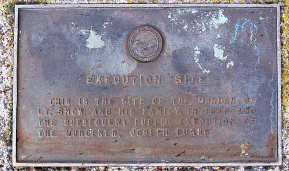
Execution Site
Two minutes along King Edward Parade a plaque can be found on the right hand side overlooking the sea. It is here where Lieutenant Robert Snow (the first commander of the early naval depot), his wife and their two daughters were murdered and later Joseph Burns was sentenced to death. Burns, Snows former shipmate, was hanged for his capital crime and was the first European to be officially executed in New Zealand.
Arrival of the French
About a 15 minute walk towards the end of King Edward Parade you’ll find Torpedo bay below North Head, named after the torpedo boat based here in the 1890’s. At the far end of the bay a plaque commemorates the visit by the French corvette L’Astrolabe in 1827 and its commander, Dumont D’Urville. D’Urville landed here and climbed Mt Victoria to survey the harbour.
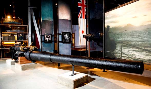
Torpedo Bay Navy Museum
At the end of King Edward Parade you’ll find Torpedo Bay Naval Museum. The perfect place to learn more about The Royal New Zealand Navy and its shared history with Devonport. The site of the museum is historical itself, developed in the 19th century as a part of Auckland’s coastal defence network. Inside these heritage buildings are a number of excellent displays and one of New Zealand’s largest collections of naval history resources. Explore a range of artefacts from personal journals to naval instruments and nautical charts, the museum is a true site for discovery and education. Torpedo Bay Navy Museum is family friendly with educational activities available for children and has an onsite café, which is the perfect place for a coffee break (for further details).
After exploring the museum continue your walk up to the North Head Historical Reserve for stunning views and unique links to Devonport’s military past. To reach North Head walk along Cheltenham Road and turn right onto Takarunga Road. At the end of this road you will find the entrance to North Head.
North Head
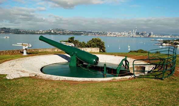
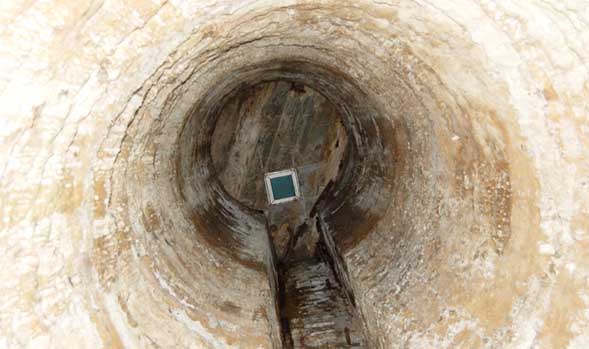
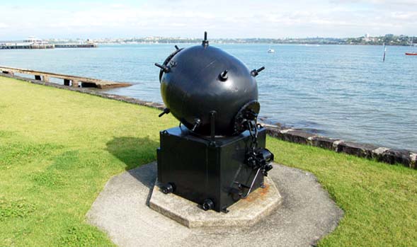
North Head is a volcanic cone and originally a Maori defensive pā before European colonization. A military tunnel complex and gun emplacements were built here during 1885 and North Head features one of the few remaining disappearing guns in the world. The military installations date from 1888 and were built to protect Auckland from a feared Russian invasion, with additions made for WW1 and WW2. The reserve is well signposted with numbered descriptions and orange markers. As well as links to the military, North Head is known for its stunning views of Rangitoto Island, the Waitemata harbour and the Hauraki Gulf. (for further details).
After exploring North Head your next stop is Mt. Victoria, Devonport’s highest volcanic cone.
To Mt Victoria from North Head:
After walking back down North Head continue back along the waterfront of King Edward Parade the way you came. When you reach Windsor Reserve turn right onto Victoria Road and walk up Devonport’s high street. If you need a quick break or some retail therapy, Victoria Road is lined with boutique shops and cosy cafés. Near Victoria Picture Palace (the earliest purpose built cinema still in existence in the southern hemisphere) Victoria Road turns slightly towards the left, however, you want to take the road to the right- Kerr Street. Across the road and on the left of Kerr Street you will see the main entrance up to Mt Victoria. Follow the road upwards to reach Mt Victoria.
Signalman’s house
On Mt. Victoria’s upper slopes you will find the Signal House, which in the past was used to inform residents about the arriving and departing ships. Many houses in the Devonport area were built to provide a direct line of site to the signal station so the inhabitant’s could easily read the flags. Whilst the first signalmen lived in a tent or hut, later a Victorian styled villa was built to house the signalman and his family. The last signalman to live in this villa passed away in 1943. Today the Signalman’s House is the Michael King Writer’s Centre which both supports and promotes New Zealand literature.
Mt Victoria
Mt. Victoria is the highest of Devonport’s volcanic cones, first occupied by a Maori pā (Maori village or defence settlement) and later developed by Europeans as a means of protection from invasion. Evidence of the mountain’s historical uses such as pā terraces and pits, and one of Devonport’s disappearing guns can still be seen on the slopes today. Historically, Mt. Victoria has been used for artillery emplacements, farmland and various concrete army bunkers. One bunker is now home to the Devonport Folk Club. With some of the best views in Auckland, the top of Mt Victoria provides a panoramic scene of the Waitemata Harbour and Hauraki Gulf, unique to this viewing point (for further details).
If you are short on time you can finish the Military History Trail here. Walk back down Mt Victoria and you will come out onto Kerr Street. Continue down this street and turn left at the bottom of the road back onto Devonport’s high street, Victoria Road. Make your way down Victoria Road and you will find yourself back at Devonport Wharf where you can take a 12 minute ferry ride back to Auckland City.
If time permits, a trip to Fort Takapuna is a fantastic way to end the Military History Trail. Fort Takapuna is a lookout point and bunker defence site and the last of the New Zealand designed twin 6 inch gun forts in existence. Fort Takapuna can be reached by bus from Victoria Road or on foot from North Head.
By Bus to Fort Takapuna from Victoria Road:
Walk back down Mt Victoria and you will come out onto Kerr Street. Continue down this street and turn left at the bottom of the road back onto Devonport’s high street, Victoria Road. On the right hand side of Victoria Road there are a number of bus stops that will take you to Fort Takapuna. One of these is outside Bayley’s real estate agents opposite the Fish and Chips Café. From here take the quick ten-minute 813 bus trip to Fort Takapuna. Buses depart from this stop every hour from 10:16 am and every half hour from 3:16pm. For more information on bus routes please visit www.maxx.co.nz
On Foot to Fort Takapuna from North Head:
Walking (one way) to Fort Takapuna will take approximately half an hour and is a beautiful waterfront stroll. After exploring North Head take the north facing steps down the side of the mountain facing the Hauraki Gulf. At the bottom of the stairs you will come out onto Cheltenham beach, popular with locals and visitors for swimming, strolling and relaxing. Walk right along Cheltenham beach to the end and take the Bath Street exit to your left. To the left on Vauxhall road you will see a few shops and cafes. If you want to pick up some treats for a picnic visit one of Devonport’s best-kept secrets, Châteaubriant. Châteaubriant is an authentic French café with delicious flaky pastries, tarts, crusty baguette sandwiches and delicious coffee. Alternatively, turn right and walk along Vauxhall Road and up the hill; continuing along until you see a naval barrack. Next to the barrack is a large grassed area, overlooking the sea is Fort Takapuna.
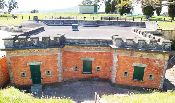
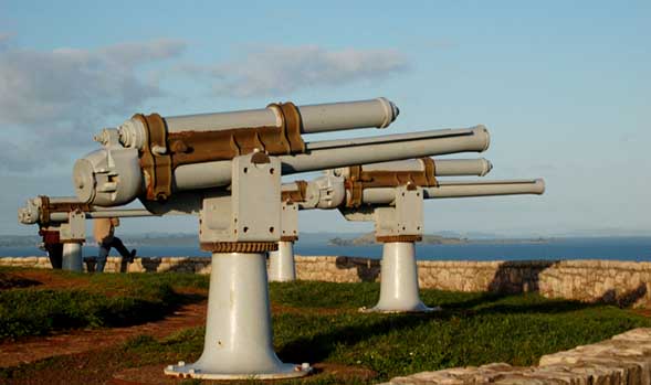
Fort Takapuna
Your final destination is Fort Takapuna, originally built as one of a number of new defence forts established around Auckland’s harbor. Fort Takpuna’s unique location at the head of the Rangitoto Channel made it an important lookout point and defence site for a number of years. The fort is below ground level as originally a dry moat surrounded the fort on all sides, with a drawbridge to provide access. Whilst the majority of the fort was filled in 100 years ago, the remaining elements are open left to explore. Take a self-guided walk to explore the barracks, tunnels, gun pits and magazine inside the last of the New Zealand designed twin 6 inch gun forts. Learn more about the installations from information panels on the walls inside the fort wall.
Located next to Fort Takapuna is Narrow Neck beach, this picturesque location is perfect for photo taking, relaxing in the sun with an ice cream or cold drink from the neighbouring café, after exploring the military surroundings.
After your time at Fort Takapuna you can either take the bus or walk back to the Devonport Wharf. The 813 bus departs from the far end of Narrow Neck beach every half hour starting at 9:56am and will take you right back to the ferry building. If you choose to walk, head back along Vauxhall Road, walk down the hill, continue past the set of shops and take a right onto Albert Road. Continue along this road, walk past the round about and at the end turn left onto Victoria Road. Walk along Devonport’s high street back towards the sea and you’ll find yourself, once again outside the Devonport Wharf.
Maori History Trail
FAMILY FRIENDLYThe Maori History Trail is a great introduction to the unique indigenous history of Devonport and its links to the settlement of Maori in Auckland. Discover the landing site of one of the first Maori Wakas to New Zealand, two Maori pā sites and the grave of esteemed Maori Chief Eru Patuone.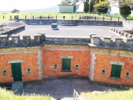
Fort Takapuna Devonport
FAMILY FRIENDLYFort Takapuna is a lookout point and bunker defence site and the last of the New Zealand designed twin 6 inch gun forts in existence. The fort is below ground level as originally a dry moat surrounded the fort on all sides, with a drawbridge to provide access.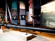
Devonport History Trail
FAMILY FRIENDLYThe History Trail is a must-do for history buffs or those wanting to further explore the fascinating history of one of Auckland’s oldest areas. Discover two volcanic cones, iconic Devonport architecture and historic sites and memorials dedicated to commemorating Devonport’s unique role in New Zealand history.